
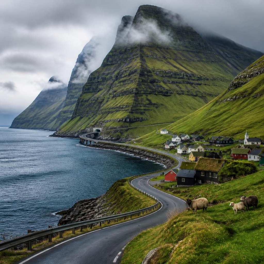
Far out in the North Atlantic Ocean lies a group of islands that looks almost unreal. Green mountains rise sharply from the sea, waterfalls pour down cliffs, tiny villages sit beside narrow fjords, and roads disappear into tunnels beneath the ocean. 🌊
This is the Faroe Islands—a remote North Atlantic archipelago where the landscape is dramatic, the weather changes quickly, and the ocean seems to be present everywhere you go.
The Faroe Islands are made up of 18 main mountainous islands located between Iceland, Norway, and Scotland. They are a self-governing territory within the Kingdom of Denmark, but they have their own language, culture, traditions, and distinct identity.
What makes the Faroe Islands especially fascinating is the way modern infrastructure blends into an ancient landscape. You can drive through a mountain tunnel, cross a bridge over the sea, or travel through an undersea tunnel before suddenly arriving at a village surrounded by cliffs and green hills.
It is a place where roads do not simply connect towns.
Sometimes, they seem to connect entire pieces of the ocean.
A Landscape Built by Fire and Ice
The Faroe Islands were not shaped by gentle geological forces. Their dramatic scenery was created by enormous volcanic activity millions of years ago.
The islands are made largely from layers of basalt formed by ancient volcanic eruptions. Over time, these layers were carved and reshaped by wind, rain, waves, and glaciers.
That combination produced the landscape the islands are famous for today:
- Tall, flat-topped mountains.
- Narrow valleys.
- Deep sea cliffs.
- Green slopes.
- Waterfalls.
- Rocky coastlines.
- Small natural harbors.
- Isolated offshore sea stacks.
The cliffs often appear almost perfectly vertical, as though someone sliced through the mountains with a giant blade. In reality, they are the result of repeated volcanic layers being exposed and eroded over immense periods of time.
The Faroe Islands are also heavily influenced by the North Atlantic climate. Rain and mist are common, and the weather can change from sunshine to fog or strong wind within minutes.
This gives the islands an atmosphere that can feel both peaceful and mysterious. A mountain may be clearly visible in the morning, hidden behind clouds by noon, and glowing in the evening light a few hours later.
Eighteen Islands, Hundreds of Views
Although the Faroe Islands cover a relatively small area, their geography is remarkably varied.
The 18 main islands are connected through a combination of roads, bridges, ferries, and tunnels. Some islands are connected directly, while others still depend on boats or helicopters for transport.
Each island has its own character.
Some are known for dramatic cliffs and seabird colonies. Others contain wide valleys, peaceful villages, or famous viewpoints. Several islands are home to only a small number of people, giving them a feeling of remoteness that is difficult to find in more densely populated parts of Europe.
The largest island is Streymoy, where the capital, Tórshavn, is located. Other well-known islands include Vágar, Eysturoy, Sandoy, Borðoy, Kalsoy, and Mykines.
The names may look unfamiliar to visitors, but the islands are deeply connected through centuries of seafaring, farming, fishing, and local traditions.
Tórshavn: One of the World’s Small Capitals
The capital of the Faroe Islands is Tórshavn, a small city with a population far below that of most national capitals.
Its name refers to Thor, the Norse god of thunder, and means roughly “Thor’s harbor.”
Tórshavn is one of the oldest parliamentary meeting places in the world. The traditional gathering site, known as Tinganes, is especially famous for its narrow lanes and red wooden buildings with grass-covered roofs.
Walking through Tinganes can feel like stepping into a storybook village. The buildings are compact, colorful, and closely packed together. Some have dark wooden walls, white-framed windows, and roofs covered in living grass.
The grass roofs are not merely decorative. In the North Atlantic climate, they provide insulation and help protect buildings from wind and rain.
Tórshavn is also the cultural center of the islands. It contains museums, cafés, restaurants, shops, music venues, and government buildings. Although it is small, it serves as the main gateway to understanding modern Faroese life.
The city demonstrates one of the central characteristics of the Faroe Islands: traditional ways of living exist alongside modern infrastructure.
The Roads That Travel Beneath the Sea
One of the most remarkable things about the Faroe Islands is their tunnel network.
Because the islands are mountainous and separated by narrow stretches of ocean, building ordinary roads across the landscape is often difficult. Engineers have therefore constructed tunnels through mountains and beneath the seabed.
The undersea tunnels are particularly impressive.
Instead of taking a ferry between certain islands, drivers can travel through long underground passages beneath the ocean. These tunnels allow residents to commute, transport goods, visit hospitals, attend school, and travel between communities more easily.
Some tunnels are modern, brightly lit, and carefully engineered. Others are narrower and more traditional in design.
One of the most visually striking examples is the Eysturoyartunnilin, or Eysturoy Tunnel. This undersea tunnel connects Streymoy and Eysturoy and includes a large underwater roundabout.
The roundabout is not simply a practical traffic junction. It has been designed as an artistic space, with lighting and sculptural elements that make the drive feel almost futuristic.
Imagine descending into darkness beneath the Atlantic Ocean, driving through a tunnel, and suddenly arriving at a glowing roundabout deep below the seabed.
It is one of the clearest examples of how the Faroe Islands combine engineering with creativity.
A Tunnel With an Underwater Roundabout
The underwater roundabout in the Eysturoy Tunnel is one of the most unusual road features in the world.
Rather than constructing a simple junction, the designers created a circular space with a central sculptural installation. The lighting gives the area a soft blue appearance, making it feel more like an underwater art gallery than a normal road.
The tunnel system was created to improve travel between important communities. But it also became an attraction in its own right.
This is a recurring theme in the Faroe Islands. Infrastructure is often built to solve a practical problem, yet the surrounding landscape and design make the journey memorable.
A tunnel is not just a tunnel when it passes beneath the Atlantic Ocean.
A roundabout is not just a roundabout when it is surrounded by rock, darkness, and carefully designed light.
The Village of Gasadalur and Its Famous Waterfall
One of the most recognizable sights in the Faroe Islands is the waterfall at Gásadalur, a small village on the island of Vágar.
The waterfall, known as Múlafossur, drops directly from a grassy cliff into the ocean. When the wind is strong, the falling water can be blown sideways, creating a misty spray that appears to float back toward the land.
For many years, Gásadalur was one of the most isolated villages in the islands. Reaching it required a difficult hike over the mountains or travel by boat.
That changed when a road tunnel opened in the early 2000s.
The tunnel made the village much easier to reach, but it did not remove its remote character. Gásadalur remains a small settlement surrounded by steep mountains and open sea.
The village shows how modern roads can transform everyday life in isolated communities. A journey that once required considerable effort became accessible by car, yet the landscape still feels almost untouched.
Mykines: The Island of Puffins
The island of Mykines is famous for its birdlife, particularly its Atlantic puffins.
Puffins are small seabirds with colorful beaks, dark backs, white faces, and bright orange feet. They spend much of their lives at sea and return to land during the breeding season.
In Mykines, visitors may see puffins nesting along grassy cliffs and rocky slopes. The island is also known for its lighthouse and a footbridge leading toward a small islet.
The bridge crosses a narrow gap above the sea, creating a dramatic walking experience. On windy days, the combination of cliffs, waves, birds, and open sky can make the crossing feel thrilling.
However, the Faroe Islands are not simply a place where visitors observe nature from a distance. The islands are also home to people who have lived alongside these landscapes for generations.
The weather, ocean, and bird populations influence local life, food, traditions, and seasonal activities.
Why Everything Looks So Green
Photographs of the Faroe Islands often show mountains covered in intense green grass. The color can look almost artificial, but it is a natural result of the local environment.
The islands receive frequent rainfall, and the cool climate limits the growth of many trees. Instead of dense forests, much of the landscape is covered by grasses, mosses, low plants, and grazing land.
Sheep are an important part of Faroese life and are found throughout the islands. They graze on hillsides, near roads, and around villages.
The absence of large natural forests also contributes to the open appearance of the landscape. Mountains and cliffs are clearly visible, while the green slopes seem to roll directly into the sea.
The result is a scenery that looks carefully designed, even though it was created by geology, climate, animals, and time.
A Place With Very Few Trees
Visitors often notice that the Faroe Islands have far fewer trees than many other places at similar northern latitudes.
Several factors contribute to this.
The islands are exposed to powerful Atlantic winds, which make it difficult for trees to grow tall and remain stable. The cool, wet climate also favors grassland and low vegetation. In addition, centuries of human settlement and grazing have influenced the landscape.
This does not mean that trees cannot grow in the Faroe Islands. Some trees are planted in protected areas, gardens, and towns. But large natural forests are not a defining feature of the islands.
Instead, the landscape is dominated by open hills, grassy mountains, rocky cliffs, and broad views of the ocean.
For many visitors, this openness is part of the islands’ beauty. There are few visual distractions between the viewer and the horizon.
The Weather Can Change in Minutes
The Faroe Islands are located in the North Atlantic, where weather systems move quickly across the ocean.
A clear morning can become foggy by midday. Sunshine can be followed by rain, strong wind, or low clouds. A mountain that looked close may suddenly disappear behind mist.
This unpredictability is one reason the islands are so visually dramatic.
Fog can make familiar landscapes look mysterious. Sunlight breaking through clouds can illuminate one mountain while leaving the surrounding valleys in shadow. Rain can create temporary waterfalls along cliffs and slopes.
For travelers, the weather also requires preparation. Waterproof clothing, sturdy footwear, and flexible plans are essential.
The Faroe Islands are not a destination where the weather simply forms a background to the trip.
The weather is part of the experience itself.
The Faroese Language and Nordic Heritage
The people of the Faroe Islands speak Faroese, a North Germanic language related to Icelandic and Norwegian.
The language developed from the speech of Norse settlers who arrived in the North Atlantic during the Viking Age. Although Faroese shares roots with other Scandinavian languages, it has developed its own pronunciation, vocabulary, and written traditions.
Danish is also used in official and educational contexts, while English is widely understood, especially in tourism and business.
Faroese culture reflects both its Nordic heritage and its island environment. Traditional music, chain dancing, storytelling, wool clothing, boatbuilding, and maritime traditions remain important parts of local identity.
The islands have also developed distinctive architectural traditions. Turf-roofed houses, brightly painted wooden buildings, and compact villages are common visual features.
The result is a culture that feels unmistakably Scandinavian but is also shaped by isolation, the sea, and the challenges of living on small islands.
Sheep Are Everywhere
The name “Faroe” is often associated with sheep, and sheep are indeed one of the most recognizable parts of the islands.
Sheep have been raised in the Faroe Islands for centuries. They are well suited to the cool climate and grassy terrain, and they have played an important role in local food, clothing, and farming traditions.
The animals can often be seen wandering across hillsides or standing near roads. In some places, they seem to appear in almost every landscape photograph.
Their wool has traditionally been used to make warm clothing and textiles, an important resource in a region where the weather can be cold, wet, and windy.
Sheep are not simply agricultural animals in the Faroe Islands. They are part of the cultural and visual identity of the place.
A road trip through the islands would feel incomplete without seeing at least a few sheep looking calmly toward the passing traffic.
The Ocean Shapes Daily Life
The Faroe Islands are surrounded by the North Atlantic, so the sea has always been central to life there.
Fishing has historically been one of the most important industries. The ocean provides food, employment, transportation routes, and connections with neighboring countries.
Villages are often built around natural harbors, where boats can shelter from the open sea. Their locations reflect centuries of practical knowledge about tides, wind, waves, and access to fishing grounds.
The sea also influences the architecture of the islands. Buildings are often designed to withstand harsh weather, and roads must be carefully planned around steep slopes and coastal conditions.
Even when residents are driving through a modern tunnel or shopping in a city, the ocean is never far away.
It is part of the geography, economy, history, and imagination of the Faroese people.
Traditional Food From a Challenging Environment
Traditional Faroese food developed in a climate where growing crops was difficult and the sea was an important source of nourishment.
Fish, lamb, fermented foods, dried meat, and preserved products have historically played important roles in local cuisine.
One traditional preservation method is fermentation, which allowed food to be stored for longer periods before modern refrigeration became available. Fermented lamb and fish are associated with Faroese food traditions, although they may be unfamiliar to visitors.
Local cuisine reflects the need to make use of available resources and survive in a challenging environment.
Modern Faroese restaurants have also developed a more contemporary style of cooking, often combining local ingredients with modern techniques.
The contrast between traditional preservation methods and modern Nordic cuisine is another example of how the islands balance their past and present.
The Faroe Islands Are Not Completely Untouched
The Faroe Islands can appear wild and remote, but they are not an untouched wilderness.
People have lived there for many centuries. Villages, roads, tunnels, farms, harbors, and power infrastructure are spread across the islands.
The landscape is therefore a combination of natural forces and human adaptation.
A grassy mountain may contain an ancient walking route. A dramatic cliff may overlook a fishing village. A quiet valley may be connected to the rest of the country by a modern tunnel.
This mixture is part of what makes the Faroe Islands interesting. They are not simply beautiful because they are empty. They are beautiful because people have learned to live within a demanding landscape without completely overwhelming it.
A Destination for Slow Travel
The Faroe Islands are not usually visited for crowded beaches, large shopping centers, or busy nightlife.
They are better suited to slow travel.
Visitors come to walk along cliffs, explore villages, watch seabirds, photograph waterfalls, experience changing weather, and enjoy long drives through dramatic scenery.
A journey may involve stopping frequently because every bend in the road reveals a new view.
One moment, the road may pass between green mountains. The next, it may open toward a fjord. A short drive later, the landscape may become rocky and windswept.
The islands reward patience. The best views are not always visible immediately, and the weather may require waiting for clouds to lift.
The experience is less about checking off attractions and more about spending time inside the landscape.
Roads That Feel Like the Edge of the World
The phrase “where roads meet the ocean” captures something essential about the Faroe Islands.
Roads often follow the edges of fjords, climb steep mountain slopes, pass through tunnels, or lead toward villages that appear almost too small to exist.
In some places, the sea is visible from nearly every direction. In others, the road disappears into a mountain and emerges on the opposite side of an island.
The infrastructure is impressive, but it never completely dominates the scenery. The mountains remain enormous, the ocean remains powerful, and the villages remain small.
That balance creates the feeling that modern life has been carefully placed inside an ancient landscape.
The road may be made of asphalt, but beyond it are cliffs shaped by volcanic eruptions, valleys carved by ice, and waves that have been striking the coastline for thousands of years.
A Small Place With a Huge Personality
The Faroe Islands are geographically small, but they have an extraordinary presence.
Their dramatic cliffs, colorful villages, undersea tunnels, grass-roofed houses, seabirds, sheep, and unpredictable weather create a landscape unlike almost anywhere else.
They also offer an interesting lesson in human adaptation.
The people of the Faroe Islands have built roads through mountains, tunnels beneath the sea, and communities in places that appear difficult to inhabit. At the same time, they have preserved a strong cultural identity shaped by language, tradition, and the ocean.
The islands remind us that remote places are not necessarily disconnected places.
A village may be surrounded by sea and mountains, yet linked to the wider world through roads, tunnels, ferries, technology, and centuries of maritime history.
Where Nature and Engineering Meet
The Faroe Islands are fascinating because they bring together two forces that seem completely different.
Nature has created steep mountains, deep fjords, powerful waves, and isolated islands. Humans have responded by building roads, bridges, tunnels, villages, and harbors.
Neither side completely overwhelms the other.
The result is a place where a modern car can travel beneath the Atlantic Ocean, where a waterfall can plunge directly into the sea, and where houses with grass roofs sit beneath mountains covered in green.
The Faroe Islands are more than a beautiful destination. They are a reminder of how people adapt to difficult environments while remaining deeply connected to the natural world.
Continue Your Journey
If you enjoyed exploring the remote landscapes of the Faroe Islands, continue your journey with our previous article:
The Strange Reason Airplane Food Tastes Different
Share the Curiosity 🌍
If the Faroe Islands surprised you, share this article with someone who loves remote destinations, dramatic landscapes, unusual roads, or hidden places around the world.
- Facebook: https://facebook.com/Trivialwiki
- Instagram: https://instagram.com/trivialwiki
- YouTube: https://youtube.com/@trivialwiki
- Pinterest: https://pinterest.com/Trivialwiki
What Do You Think?
Would you rather explore the Faroe Islands by driving through its undersea tunnels, hiking along its dramatic cliffs, or visiting one of its tiny villages surrounded by the ocean?
1 thought on “The Faroe Islands: Where Roads Meet the Ocean”